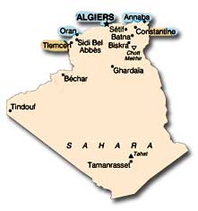
Algeria: GEOGRAPHY
GEOGRAPHY
Location: Algeria is located in northwestern Africa, bordering the
Mediterranean Sea between Morocco and Tunisia.
Size: Algeria has an area of almost 2.4 million square kilometers,
more than four-fifths of which is desert. Nearly 3.5 times the size
of Texas, Algeria is the tenth largest country in the world and the
second largest in Africa.
Land Boundaries: Algeria shares borders with Morocco
(1,559 kilometers), Mali (1,376 kilometers), Libya (982 kilometers), Tunisia (965 kilometers), Niger (956 kilometers), Mauritania (463 kilometers), and Western Sahara (42 kilometers).
Disputed Territory: Algeria has border disputes with Morocco and Libya. Disagreements between Algeria and Morocco concern smuggling activities along the border, jurisdiction over territory in southeastern Morocco, and Morocco’s claim to Western Sahara. Libya claims 32,000 square kilometers of southeastern Algeria.
Length of Coastline: Algeria’s 998-kilometer northern border stretches along the southern edge of the Mediterranean Sea from Morocco in the west to Tunisia in the east.
Maritime Claims: Algeria claims a territorial sea of 12 nautical miles and an exclusive fishing zone of 32–52 nautical miles.
Topography: A sharp contrast exists between the relatively fertile, mountainous, topographically fragmented north, dominated by parallel ranges of the Atlas Mountains, and the vast expanse of the Sahara Desert in the south. The fertile Tell region in the north, extending eastward from the Moroccan border, is the country's heartland, containing most of its cities and population. The Tell is made up of the hills and plains of the narrow coastal region, several Tell Atlas mountain ranges, and intermediate valleys and basins. South of the Tell, the High Plateaus region stretches more than 600 kilometers eastward from the Moroccan border. This region consists of undulating, steppe-like plains lying between the Tell Atlas Mountains to the north and the Saharan Atlas mountains to the south. The High Plateaus region averages between 1,100 and 1,300 meters in elevation in the west, dropping to 400 meters in the east. Northeastern Algeria consists of a massif area extensively dissected into mountains, plains, and basins. It differs from the western portion of the country in that its prominent topographic features do not parallel the coast. The Algerian portion of the Sahara extends south of the Saharan Atlas for 1,500 kilometers to the borders with Niger and Mali. The desert is an otherworldly place, scarcely considered an integral part of the country. Far from being covered wholly by sweeps of sand, it is a region of great diversity. Immense areas of sand dunes occupy about one-quarter of the territory. Much of the remainder of the desert is covered by rocky platforms, and almost the entire southeastern quarter is taken up by highlands.
Principal Rivers: Algeria’s largest river, the Chelif, flows 725 kilometers from the Tell Atlas into the Mediterranean Sea.

Click to Enlarge Image
Climate: The coastal lowlands and mountain valleys are characterized by a Mediterranean climate, mild winters, and moderate rainfall. In this densely populated region, temperatures average between 21° C and 24° C in the summer and drop to 10° C to 12° C in the winter. Average temperatures and precipitation are lower in the intermountain High Plateaus. The desert is hot and arid. Most of the country experiences little seasonal change but considerable diurnal variation in temperature. Rainfall is fairly abundant along the coastal part of the Tell, ranging from 400 to 670 millimeters annually, the amount of precipitation increasing from west to east. Precipitation is heaviest in the northern part of eastern Algeria, where it reaches as much as 1,000 millimeters in some years. Farther inland the rainfall is less plentiful.
Natural Resources: Algeria’s natural resources consist of petroleum, natural gas, iron ore, phosphates, uranium, lead, and zinc. Algeria has proven oil reserves of 11.8 billion barrels, a relatively modest amount. Proven natural gas reserves are estimated at 160 trillion cubic feet, the eighth largest in the world.
Land Use: In 2001 Algeria’s land use was as follows: 3.22 percent, arable; 0.25 percent, permanent crops; and 96.56 percent, other. More than four-fifths of Algeria’s territory is desert.